on the grid
on the grid
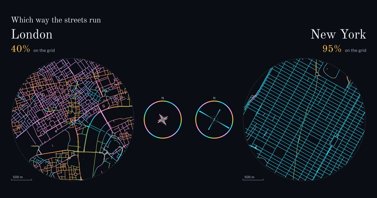
Two cities at the same scale, 3 km across. Each street is coloured by the compass direction it runs, and two streets that cross at a right angle get the same colour. A grid has only two directions, at right angles, so its whole map is one colour. Where streets point every way, the map is every colour.
on the grid
on the grid
A grid is not a modern idea. Kyoto was laid out in 794 and 88% of its streets still run its two ways; Beijing, from 1267, holds 80%. Dubai’s downtown, built since 2004, holds 65%. London’s best pair of directions holds 40%, Istanbul’s 23%, and streets running every way alike would hold 17%.
In a city that grew, look for patches of one colour. Each is a small grid of its own, set at its own angle to the ones around it.
Running the same way is not the same as meeting. In New York three junctions in four are crossroads. In Beijing, a grid as well, one in five is, and two in three are T-junctions, where a street ends at another. Venice has the shortest walk between corners, 32 m, and the most dead ends, one junction in three.
| City, and the middle of its map | On the grid | Main direction | Crossroads | T-junctions | Dead ends | Between corners | Street per km² |
|---|---|---|---|---|---|---|---|
| IstanbulEminönü | 23% | 36° east of north | 28% | 60% | 13% | 43 m | 20.2 km |
| ParisNotre-Dame | 49% | 24° east of north | 39% | 51% | 10% | 63 m | 22.8 km |
| LondonTrafalgar Square | 40% | 30° west of north | 29% | 53% | 18% | 53 m | 21.4 km |
| VeniceRialto Bridge | 26% | 20° east of north | 28% | 40% | 32% | 32 m | 19.3 km |
| Fezal-Qarawiyyin | 22% | 27° west of north | 24% | 51% | 25% | 45 m | 14.6 km |
| KyotoShijō Karasuma | 88% | 3° east of north | 47% | 45% | 8% | 67 m | 23.0 km |
| BeijingDrum Tower | 80% | 2° west of north | 19% | 67% | 14% | 85 m | 15.1 km |
| New YorkTimes Square | 95% | 28° east of north | 76% | 16% | 8% | 84 m | 17.2 km |
| BarcelonaPlaça de Catalunya | 64% | 44° west of north | 48% | 39% | 13% | 61 m | 28.4 km |
| TokyoShibuya Crossing | 26% | 36° east of north | 28% | 56% | 16% | 53 m | 24.8 km |
| BrasíliaThe cathedral | 61% | 18° east of north | 19% | 60% | 21% | 79 m | 10.9 km |
| DubaiBurj Khalifa / Dubai Mall station | 65% | 34° east of north | 21% | 70% | 9% | 65 m | 13.7 km |
The streets are OpenStreetMap’s, within 1.5 km of the same spots as No. 014. A street here is a road of any class below a motorway, an alley, or a footway that has a name, which is what the streets of Venice and of the Fez medina are. Tunnels, service roads, sidewalks and paths without a name are left out.
A street’s direction is taken piece by piece, so a bending street has several colours. “On the grid” is the share of street length within 7.5° of the two directions, at right angles to each other, that hold the most street. The compass shows the share of street length in each 5° of direction; a petal’s area is its share, and the dashed ring is where every petal would end if streets ran every way alike. The colours on its rim are the key to the map.
Junctions within 15 m of each other count as one, so a street crossing both sides of a divided road is one crossroads. “Between corners” is the median length of street from one junction to the next.
Map data © OpenStreetMap contributors.